In the fall of 2011, GFNMS in partnership with US Geological Survey (USGS) and NOAA's National Centers for Coastal Ocean Science (NCCOS), conducted multibeam surveys to better define the bottom habitats of the sanctuary. The multibeam data revealed highly detailed images of several significant underwater geologic features off San Francisco and Marin counties in NOAA's Gulf of the Farallones National Marine Sanctuary. These underwater features can now be seen for the first time ever through the release of an animated 3-D "flythrough" which can be viewed below.
This "flythrough" video shows highly detailed maps of topography and substrate type for Rittenburg Bank, Farallon Escarpment and Cochran Bank (labeled as "West Fanny Shoal" in the video). The video wa was produced by NOAA's National Centers for Coastal Ocean Science, USGS, and GFNMS.
In October 2012, the sanctuary explored and mapped Rittenburg Bank, Cochrane Bank, and the Farallon Escarpment. View a video of these special underwater places. The objectives of this cruise were to:
- To locate and characterize deep-sea coral and sponge habitats;
- To collect information to help understand the value of deep-sea corals and sponges as reservoirs of biodiversity, or habitat for associated species, including commercially important fishes and invertebrates;
- To assess the condition of coral and sponge assemblages in relation to potential anthropogenic or environmental disturbances; and
- To make this information available to support fisheries and sanctuary management needs under MSA and NMSA requirements.
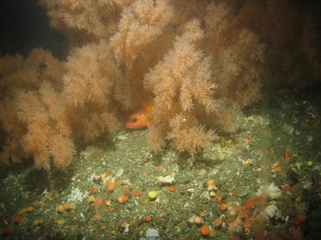
Deep-sea coral and sponge communities are key "living habitats" for other sea life in the marine ecosystem. The October 2012 research cruise used a remotely operated vehicle (ROV) with cameras to explore the target areas. The 2012 expedition documented marine debris and establishes baseline water quality conditions as they relate to potential impacts of ocean acidification on deep-sea corals.

Rittenburg Bank is approximately 50 kilometers (31 mi) off the Marin county coast and lies at depths ranging from approximately 50 to 150 meters. Rittenburg Bank has a high density of sponges at its northwest region, 184 sponges per 1000 m2, consisting of at least nine taxa of sponges. There are at least 35 taxa of fishes with a density of 139 fish per 1000 m2 and six taxa of anthozoans (corals), with a density of 138 anthozoans per 1000 m2.
Cochrane Bank is the deepest known rocky bank within GFNMS ranging from 70 to 150 meters (230-490 ft) and is 68 kilometers (42 mi) west of San Francisco. Cochrane Bank has the long-lived coral Antipathes dendrochristos, a species previously thought to be endemic to Southern California, but Cochrane Bank is now believed to be the northern extent of its range. Cochrane Bank has at least 27 taxa of fishes, with a density 165 fish per 1000 m2, nine taxa of sponges, with a density of 64 sponges per 1000 m2, and at least five taxa of anthozoans, with a density of 147 anthozoans per 1000 m2.
The Farallon Escarpment ranges in depth from 180 to over 2000 meters in depth. Only a small fraction of the Escarpment was surveyed but surveys revealed extensively dissected submarine canyons and gullies, which stretch from the shelf break (approximately 150 m depth) down to the deep basin. In the heads of canyons, slumping and ocean currents deposit fine sands and muds. There is hard substrate that is covered in a layer of fine silt and supports many infaunal benthic invertebrates. Previous interpretations of the geology of this area suggested primarily soft substrate. At least 10 taxa of fishes were identified with an estimated average density of 49 fish per 1000 m2. The majority of the fish were rockfish species. Seven taxa of sponges were identified, with an average density of 29 sponges per 1000 m2 of sea floor. There were at least seven taxa of anthozoans, with an average density of 86 anthozoans per 1000 m2 of sea floor.
A technical report (PDF, 3Mb), detailing the characterization of these three areas can be found at this link. Minimum count and distribution data are available on line at the Essential Fish Habitat Data Catalog.

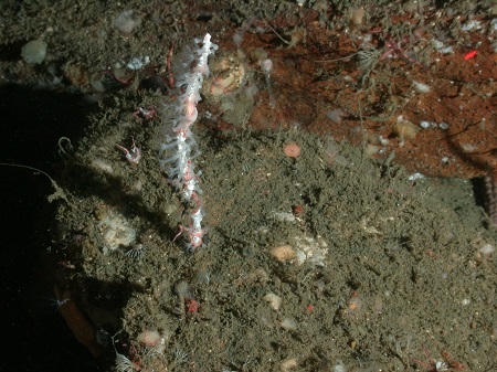
A new species of whip-like gorgonian coral, Swiftia farallonesica, discovered at The Football in 2014. Click to enlarge.
In October 2014, another ROV research cruise explored a mixed soft and rocky bottom area, informally called The Football, which is approximately 37 km (23 miles) west of Jenner and the mouth of the Russian River, in Sonoma County. This was a joint research cruise with Cordell Bank sanctuary, USGS, National Centers for Coastal and Ocean Science, and California Academy of Sciences. The Football ranges in depth from 150 m to 350 m deep (490 ft to 1,100 ft). During this research cruise, a new species of coral was identified, Swiftia farallonesica. Characterization of The Football can be found at our national web site, Conservation Science publication series.

