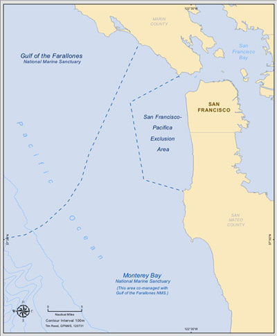
San Francisco - Pacifica Exclusion Area
In accordance with section 304 of the National Marine Sanctuaries Act, as amended, (NMSA) (16 U.S.C. 1431 et seq.), the Office of National Marine Sanctuaries (ONMS) of the National Oceanic and Atmospheric Administration (NOAA) initiated a review of Monterey Bay National Marine Sanctuary (MBNMS or sanctuary) boundaries, to evaluate the opportunity and effects of expanding the sanctuary's boundary. The process steps undertaken, as required by the National Marine Sanctuaries Act, have been conducted.
Read the full Federal Register Notice, published Aug 7, 2012.
Public Comment
Public comment was received by the Oct 10, 2012 deadline published in the Federal Register.
Background
Monterey Bay National Marine Sanctuary, designated in 1992, is a Federally protected marine area offshore of California's central coast. Stretching from Marin to Cambria, the Monterey Bay National Marine Sanctuary encompasses a shoreline length of 276 miles and 6,094 square miles of ocean, extending an average distance of 30 miles from shore. At its deepest point, the MBNMS reaches down 12,713 feet (more than two miles).
When MBNMS was designated, the urban waters of San Francisco, Daly City, and Pacifica were deemed incompatible with sanctuary regulations and excluded from MBNMS designation. This unprotected area is referred to as the San Francisco-Pacifica Exclusion Area. The following activities taking place at the time of MBNMS designation were listed as reasons for excluding the region:
- Pollution problems stemming from the combined sewer overflow component of the City and County of San Francisco's sewage treatment program;
- High vessel traffic in the area;
- Potential pollutants from dredge spoils deposited in the exclusion area.
The Sanctuary has received reports that these three conditions are no longer valid issues for exclusion of this area. The San Francisco Public Utilities Commission (SFPUC) has been and is investing to upgrade the combined sewer system and build green infrastructure. Recommended vessel traffic patterns have been moved offshore of the exclusion area and dredge materials are reported to be clean and are permitted under the Environmental Protection Agency.
In 2008, the Joint Management Plan Review for Cordell Bank, Greater Farallones and Monterey Bay National Marine Sanctuaries determined that NOAA would "facilitate a public process in the next five years to consider whether the exclusion area should be incorporated into MBNMS." At the February 23, 2012 and June 7, 2012 GFNMS Advisory Council meetings, the Sanctuary Advisory Council (SAC) unanimously recommended that the sanctuary superintendent explore the option of incorporating the exclusion area into MBNMS boundaries.
In accordance with Section 304 of the NMSA, ONMS initiated a review of Monterey Bay National Marine Sanctuary boundaries to "evaluate and assess a proposed expansion" for the sanctuary. NOAA proposed to add the exclusion area to the sanctuary as a way to protect additional nationally-significant seascape, wildlife, and shipwrecks; and to promote ecotourism. An expanded sanctuary could protect up to an additional seventy-seven square nautical miles (101 square statute miles), from the waters west of the Golden Gate Bridge to the current sanctuary boundaries.
Protection of Maritime Archaeological Resources
Historically important shipwrecks are located in Monterey Bay National Marine Sanctuary. The expansion of the Monterey Bay National Marine Sanctuary into the SF-Pacifica Exclusion Area would result in an increased number of maritime archaeological resources in the waters of the Sanctuary.
As part of the National Environmental Policy Act (NEPA) compliance process for the proposed expansion of the Monterey Bay National Marine Sanctuary, the NOAA Office of National Marine Sanctuaries initiated consultation with the California's State Historic Preservation Officer (SHPO), as required under Section 106 of the National Historic Preservation Act (NHPA). This consultation process allowed for a 30-day review process by SHPO and also provided the public with an opportunity to review and comment on the documentation.
Download the Section 106 consultation (474 KB, PDF) and SHPO response of "No Adverse Effect." (53Kb, PDF).
Independent Analysis
In May 2013, a group of graduate students at the BREN School of Environmental Science and Management completed an independent thesis project (PDF, 3.9Mb) which analyzed the suitability of incorporating the SF-Pacifica Exclusion Area into the national marine sanctuary (NMS) system.
As part of their analysis, they conducted research to evaluate whether the originally cited reasons for exclusion have changed and whether the characteristics of the area fulfill the sanctuary designation criteria in the National Marine Sanctuaries Act (NMSA), specifically whether the Exclusion Area's characteristics can be considered "of special national significance" under the NMSA.
Since "special national significance" has never been clearly defined by Congress or by the Office of National Marine Sanctuaries, the students conducted an analysis of how the NMSA has been interpreted and implemented over the 40-year history of the National Marine Sanctuary System. They analyzed the characteristics of the thirteen existing National Marine Sanctuaries and identified specific qualitative and quantitative thresholds that have emerged over time as standards for sanctuary designation. These thresholds, which they named "emergent sanctuary designation criteria", were then compared to the characteristics of the Exclusion Area to determine if the Area's characteristics could be deemed nationally significant, under the requirements of the NMSA.
They completed their final paper in March 2013 and presented their findings to the GFNMS Sanctuary Advisory Council (PDF, 2.3Mb) on May 22, 2013 in San Francisco. The BREN Project provides a wealth of valuable information in this final paper, which the Sanctuary hopes to utilize, as we prepare to conduct our own analysis and begin developing a Draft EIS and possible project alternatives.
For more information, contact max.delaney@noaa.gov