Tomales Bay Seagrass Protection
High concentrations of fish are found in eelgrass habitat for several reasons: it provides abundant food sources (including algae, fish, invertebrates, and detritus); it provides a hiding space for many species of fish, protecting them from predation by larger fish and birds; and eelgrass beds serve as an important nursery ground, providing a safer place for larvae and juvenile fish to feed and grow. Moreover, some species of fish use eelgrass beds for their spawning grounds, including the commercially important Pacific herring, which relies on abundant eelgrass beds to support its roe. Other commercially valuable species feed in eelgrass beds at some point in their lives as well, including Dungeness crabs, rockfish, salmon and Pacific herring.
Eelgrass beds also help to support a very large population of birds on Tomales Bay, which feed on eelgrass, fish, and invertebrates in the beds and adjacent areas. In addition to supporting fish and birds, eelgrass sustains a myriad of invertebrate species: clams, shrimp, snails, nudibranchs, amphipods, worms, and bryozoans consume tiny algae that grow on eelgrass blades and filter detritus and phytoplankton from the water. In turn, these animals provide food for many other animals that live and/or feed in eelgrass beds.
Eelgrass provides ecosystem services beyond providing habitat and food for animals. It improves water quality along the coast by trapping sediments and reducing excess nutrients and pollutants in the water column. In some cases eelgrass beds can also help to prevent coastal erosion by buffering the impacts of wave energy and storms. Currently Tomales Bay is being studied for potential benefits of eelgrass beds to sequestering carbon.
Because of their ecological importance and vulnerability to impacts from humans, eelgrass beds are protected in several different ways: they are designated as “special aquatic sites” under Section 404(b)(1) Guidelines of the Clean Water Act; designated as Essential Fish Habitat under the Magnuson-Stevens Fishery Conservation Management Act; and protected under California Department of Fish and Wildlife regulations. Moreover, GFNMS regulations offer protection through prohibiting vessel anchoring within Tomales Bay Seagrass Protection Zones.
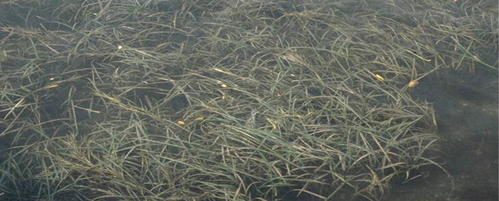
Help Protect Seagrass
The Sanctuary has taken several actions to protect seagrass, and we need your help to keep it protected. If you are planning on boating, kayaking, swimming or wading in the nearshore waters of Tomales Bay, then avoid certain actions that can impact seagrass beds. Best practices include:
- If you are kayaking and want to beach your boat, choose a location that is free of seagrass.
- When swimming or wading, be sure not to step in seagrass.
- Before anchoring, check for seagrass. If you see it, move to another location or further offshore. Eelgrass in Tomales Bay (Zostera marina) is generally found in depths less than 20 feet. Without exception, anchoring is prohibited in Seagrass Protection Zones.
Seagrass Protection Zones
Seagrass in the Sanctuary is defined as any species of marine angiosperms (flowering plants) that inhabit portions of the seabed in the Sanctuary. There are a total of seven no anchoring zones, which comprise 22% of the surface area of Tomales Bay. The location and extent of the no-anchoring zones encompass the majority of seagrass coverage within the jurisdiction of the Sanctuary and are based upon seagrass data provided by California Department of Fish and Wildlife from 1992, 2000, 2001 and 2002. The no-anchoring seagrass protection zones include some areas where seagrass coverage is extensive and other areas where coverage is discontinuous and patchy. All zones extend shoreward to the Mean High Water Line. This prohibition protects seagrass beds in Tomales Bay from harm from anchoring. View the map and coordinates (PDF, 2.5 MB) of the designated no-anchoring seagrass protection zones.
Want to know more about Seagrass in Tomales Bay? Download this presentation (PDF, 21 MB) on seagrass given by Dr. Suzanne Olyarnik, Bodega Marine Reserve Director, University of California, Davis.Public Process
Throughout the process to develop the Draft Tomales Bay Vessel Management Plan, GFNMS and CSLC were committed to engaging boaters and the local community in providing input for the development of the plan. To that end, Greater Farallones Sanctuary Advisory Council initiated a Working Group for Tomales Bay Vessel Management. The Working Group consisted of representatives of boating associations, shellfish growers, commercial fishermen, boat services operations, conservation organizations, shore-side property owners, and state and federal agencies with jurisdiction in Tomales Bay.
GFNMS and CSLC would like to thank the following Working Group participants for their contributions to the development of the Plan:
- Dominique Richard, Chair, GFNMS Advisory Council
- Colin Smith, National Park Service
- Nanci Smith, State Lands Commission
- Tom Moore, Dept. of Fish and Game
- Jerry Abbot, Inverness Yacht Club
- Mark Bartolini, Tomales Bay Boaters Association
- George Clyde, East Shore Planning Group
- John Finger, Hog Island Oyster Company
- Fred Smith, Environmental Action Committee of West Marin
- Gordon Bennett, Sierra Club
- Willy Vogler, Lawson's Landing
- Gene Maffucci, Herring Fishman
- Skip Vilicich, Marshall Boat Works
- Jeremy Fisher-Smith, Fisher-Smith Boat Works
Summaries of Working Group Meetings:
- March 27, 2008 (28Kb PDF)
- June 27, 2008 (28 kB PDF).
- July 24, 2008 (56 kB PDF).
- October 30, 2008 (76Kb PDF).
- November 12, 2008 (176Kb PDF).
Tomales Bay Interactive Map
A layered PDF was developed by GFNMS staff as a complement to the Draft Plan to provide a geographic context and visual representation of the proposed Tomales Bay Mooring Program criteria and other boating-related resources on the bay. This user-friendly interactive map enables the viewer to overlay several different map layers and to determine the geographic coordinates of specific locations without the use of specialized software. A revised version of the interactive map is being developed and will be available soon.
Previous Documents & Presentations
Vessel Usage Scoping Document
In 2007, GFNMS and CSLC produced the document, "Protecting Tomales Bay by Managing Vessel Usage: A Document for Public Input." The document was a result of a multi-agency effort to coordinate current and future vessel-related activities to improve water quality, protect wildlife and habitat, and protect public health and ensure recreational opportunities in Tomales Bay. The document presented activities currently being implemented by the participating agencies as well as proposed concepts for vessel management. The purpose of this document was to solicit vessel management recommendations from individuals and organizations in the local community and users of Tomales Bay to protect the ecosystem and public health in the bay. The document was released for a 60-day comment period and two "brainstorming" workshops were held.
Download the Draft Vessel Management Plan
- EA/IS, released Aug. 23, 2012 (PDF, 3Mb)
Download the Notice of Intent (PDF, 135Kb)
Protecting
Tomales Bay by Managing Vessel Usage: A Document for Public Input 2007
(26.2 MB PDF)
Appendix I: Government
Agency Jurisdiction and Regulation (352 KB PDF)
Appendix II: Tomales
Bay TMDL (72 KB PDF)
Appendix III:
Mooring Criteria-GIS Information for Maps (24 KB PDF)
View response to Public Comments 2008 (176 KB PDF)
Presentation by Suzanne Olyarnik, Bodega Marine Lab: Seagrass Beds
in Tomales Bay: The Unsung Heroes of Habitat (20.9MB PDF)