Tomales Bay Mooring Program
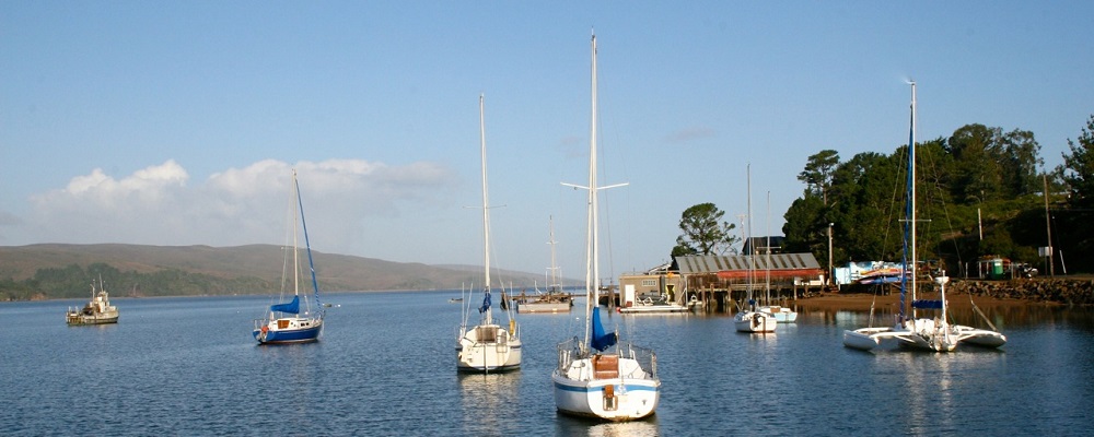
The California State Lands Commission (CSLC), in partnership with the Greater Farallones National Marine Sanctuary (GFNMS) administers the Tomales Bay Mooring Program. The Program provides specific criteria for where moorings are allowed on the bay, introduces mandatory specifications for mooring tackle, and lays out requirements for the inspection and maintenance of moorings. The primary goals for establishing a program for siting and permitting moorings on the bay are to: protect habitat, in particular eelgrass; decrease threats to and disturbance of wildlife; and ensure safe and enjoyable water-related recreation.
When the Program was initiated in August 2015, GFNMS rolled out a community-based, public process to address more than 100 non-compliant moorings in Tomales Bay. Many of these preexisting moorings were removed from eelgrass beds and the Program prohibits the placement of any future moorings in or adjacent to eelgrass. We are actively monitoring the health of the eelgrass in these locations and expect the Program to result in significant restoration and long-term protection of the eelgrass beds and other sensitive habitats of Tomales Bay, as well as improved water quality and promotion of safer water-related recreation.
This page provides essential information for those who are interested in installing a new mooring on Tomales Bay. Mooring lease applicants are required to submit a CSLC mooring lease application, and provide all required additional information as outlined in the Tomales Bay Mooring Program Requirements. CSLC will accept mooring lease applications from any party interested in applying for a mooring lease within the sovereign lands of Tomales Bay.
Applying for a Tomales Bay Mooring Lease
The following documents provide necessary information for the mooring lease application process:
- California State Lands Commission Online Lease Application
- Tomales Bay Mooring Program Requirements (PDF, 989 KB)
- Mooring Lease FAQs
- List of Approved Mooring Contractors
Tomales Bay Mooring Program Requirements:
Private vessel moorings in Tomales Bay must meet all standards outlined in the Tomales Bay Mooring Program Requirements (PDF, 1 Mb). It includes all criteria and requirements for private vessel moorings in Tomales Bay. This document should be used as the main source of information for potential Tomales Bay mooring lease applicants and mooring owners. Topics outlined in this document include:
- An overview of the Mooring Program and the purpose and need for the Program;
- An explanation of Program applicability and exemptions;
- California State Lands Commission Mooring Program lease requirements;
- Special conditions for Tomales Bay mooring leases;
- Mooring siting criteria and requirements for the location of moorings;
- Mooring tackle requirements;
- Mooring inspection and maintenance requirements;
- Information on the California State Lands Commission mooring lease application process and information submittal requirements;
- Mooring installation and positioning;
- Provisions for termination of California State Lands Commission mooring lease, and;
- Compliance monitoring and enforcement.
California State Lands Commission Lease Application
AA California State Lands Commission lease is required for all vessel moorings on Tomales Bay. The lease application is only available through the California State Lands Commission. You can access the Lease Application on the California State Lands Commission Online Portal, or can, or download the Application for Use of State Lands (PDF, 1.5 MB). Paper applications can be submitted to:
California State Lands Commission
100 Howe Avenue, Suite 100-South
Sacramento, CA 95825
Public Process
Throughout the process to develop the Draft Tomales Bay Vessel Management Plan, GFNMS and CSLC were committed to engaging boaters and the local community in providing input for the development of the plan. To that end, Greater Farallones Sanctuary Advisory Council initiated a Working Group for Tomales Bay Vessel Management. The Working Group consisted of representatives of boating associations, shellfish growers, commercial fishermen, boat services operations, conservation organizations, shore-side property owners, and state and federal agencies with jurisdiction in Tomales Bay.
GFNMS and CSLC would like to thank the following Working Group participants for their contributions to the development of the Plan:
- Dominique Richard, Chair, GFNMS Advisory Council
- Colin Smith, National Park Service
- Nanci Smith, State Lands Commission
- Tom Moore, Dept. of Fish and Game
- Jerry Abbot, Inverness Yacht Club
- Mark Bartolini, Tomales Bay Boaters Association
- George Clyde, East Shore Planning Group
- John Finger, Hog Island Oyster Company
- Fred Smith, Environmental Action Committee of West Marin
- Gordon Bennett, Sierra Club
- Willy Vogler, Lawson's Landing
- Gene Maffucci, Herring Fishman
- Skip Vilicich, Marshall Boat Works
- Jeremy Fisher-Smith, Fisher-Smith Boat Works
Summaries of Working Group Meetings:
- March 27, 2008 (28Kb PDF)
- June 27, 2008 (28 kB PDF).
- July 24, 2008 (56 kB PDF).
- October 30, 2008 (76Kb PDF).
- November 12, 2008 (176Kb PDF).
Tomales Bay Interactive Map
A layered PDF was developed by GFNMS staff as a complement to the Draft Plan to provide a geographic context and visual representation of the proposed Tomales Bay Mooring Program criteria and other boating-related resources on the bay. This user-friendly interactive map enables the viewer to overlay several different map layers and to determine the geographic coordinates of specific locations without the use of specialized software. A revised version of the interactive map is being developed and will be available soon.
Previous Documents & Presentations
Vessel Usage Scoping Document
In 2007, GFNMS and CSLC produced the document, "Protecting Tomales Bay by Managing Vessel Usage: A Document for Public Input." The document was a result of a multi-agency effort to coordinate current and future vessel-related activities to improve water quality, protect wildlife and habitat, and protect public health and ensure recreational opportunities in Tomales Bay. The document presented activities currently being implemented by the participating agencies as well as proposed concepts for vessel management. The purpose of this document was to solicit vessel management recommendations from individuals and organizations in the local community and users of Tomales Bay to protect the ecosystem and public health in the bay. The document was released for a 60-day comment period and two "brainstorming" workshops were held.
Download the Draft Vessel Management Plan
- EA/IS, released Aug. 23, 2012 (PDF, 3Mb)
Download the Notice of Intent (PDF, 135Kb)
Protecting
Tomales Bay by Managing Vessel Usage: A Document for Public Input 2007
(26.2 MB PDF)
Appendix I: Government
Agency Jurisdiction and Regulation (352 KB PDF)
Appendix II: Tomales
Bay TMDL (72 KB PDF)
Appendix III:
Mooring Criteria-GIS Information for Maps (24 KB PDF)
View response to Public Comments 2008 (176 KB PDF)
Presentation by Suzanne Olyarnik, Bodega Marine Lab: Seagrass Beds
in Tomales Bay: The Unsung Heroes of Habitat (20.9MB PDF)