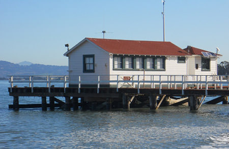
The sanctuary completed the rehabilitation of the Pier & Tide Gauge Station in June 2004, in time to celebrate 150 years of providing near continuous tidal observations of San Francisco Bay. The station is one of the country's major scientific landmarks, the oldest continually operating tidal gauge in the Western Hemisphere. The first bit of data was recorded on June 30, 1854, and this station has been providing data ever since.
Besides continuing to provide this valuable information to the world, the pier also serves as an iconic classroom and meeting space for sanctuary programs, and as a platform for other scientifc instrumentation that helps to better our understanding of the ocean and bay.
Tide Gauge Station
The NOAA Center for Operational Oceanographic Products and Services (CO-OPS) provides the national infrastructure, science, and technical expertise to monitor, assess, and distribute tide, current, water level, and other coastal oceanographic products and services that support NOAA's mission of environmental stewardship and environmental assessment and prediction. Daily tidal current predictions are available for more than 2,700 locations along the U.S. coastline. The oldest tide gauge station in the country is located here.
Although a self-registering gauge was established in San Francisco in 1853, it was decided to move the gauge to Fort Point on the grounds of the Presidio in July 1854 as portions of San Francisco were in turmoil because of land squatters causing civil unrest. Amazingly, since that time this gauge and its successors have produced the longest running unbroken series of tidal observations in the Americas. It is probable that there is no other geophysical phenomena in the Western Hemisphere that has a longer continuous record.
Station measures: Tides, Wind, Air & Water Temperature, and Air Pressure,
(Real time data and Tidal benchmarks)
Publications that highlight the history of tidal data in San Francisco:
150 Years of Tides on the Western Coast: The Longest Series of Tidal Observations in the Americas (PDF)
Tides of History (PDF), SF Chronicle, Jun 28, 2004
Tidal Bench Marks
There are four bench marks on campus permanently attached to the seawall that are part of a network of ten tidal bench marks located throughout the park, which date back to 1925. These tidal bench marks are used as vertical references by NOAA's Center for Oceanographic Products and Services (CO-OPS), through a process of surveying called geodetic leveling, to accurately measure tides and compute a number of tidal datums. In the United States, tidal datums are very important. They are used to measure heights, such as bridge heights above water, depths, such as water depths above rocks, and to determine horizontal boundaries, such as property and international boundary lines.
These bench marks and tidal datums also play a critical role in the mission of NOAA's office of National Geodetic Survey (NGS). NGS uses geodetic leveling of a nationwide bench mark network, which includes tidal bench marks, to establish geodetic datums as part of the National Spatial Reference System (PDF). The current geodetic datum for the continental US is the North American Vertical Datum of 1988. With the advance of the Global Navigation Satellite System commonly known as the Global Positioning System (GPS), NGS is utilizing Continuously Operating Reference Stations at known elevations and shorter duration GPS surveys on bench marks as part of the National Height Modernization Program.
Bodega Ocean Observing Node (BOON)
The Bodega Ocean Observing Node (BOON) is a coastal ocean observing system managed by the Bodega Marine Laboratory (BML) and focused on the coasts of northern California, from the Gulf of the Farallones to Point Arena. This station monitors the waters of San Francisco Bay.
BOON is part of the Central and Northern California Ocean Observing System (CeNCOOS), a regional association, established in 2004, in response to a growing national priority to develop and maintain a network of observing systems. CeNCOOS is part of a national framework of integrated coastal observing systems covering all U.S. coastal areas. This national framework is called the Integrated Ocean Observing System (IOOS).
Station measures: Temperature, conductivity, pressure, salinity and density measurements from a CTD. Additional sensors collected chlorophyll fluorescence and transmittance (Real time data & full sensor specifications). The historical records are available here.
Sensors that are currently in the water include:
- Seabird 16+ CTD (Water Temperature, Conductivity, Pressure, Salinity, Density)
- WETLabs C-Star Transmissometer (Water Clarity)
- Seapoint Chlorophyll fluorometer (Fluorescence/Chlorophyll-a)
Surface Currents in San Francisco Bay
NorCalCurrents provides near real-time mapping of coastal surface circulation in San Francisco Bay and along the central CA coast between Point Reyes and Pescadero. This station is one of 13 high-frequency radar (HFR) sensors operated by San Francisco State University's Romberg Tiburon Center for Environmental Studies (RTC). It is also a component of CeNCOOS.
The HFR technology was developed by Codar and is very different than that typically used to measure currents, i.e. placing current meters in the water at a few strategic lcations. Instead, land-based antennas are positioned to emit low-energy radio signals that bounce off of ocean waves and are returned to receiving antennas. The time delay, direction, and wavelength change (Doppler shift) of the returning signals allow calculation of the location, speed, and bearing of surface currents.
Station measures: Water Surface Currents (Real time data)